Key points
- Manchester City Council has launched a public consultation on a major new Strategic Regeneration Framework for the Water Street area, one of the city centre’s last large undeveloped sites.
- The plan envisages a new, largely residential neighbourhood with thousands of homes, including a significant proportion of affordable housing.
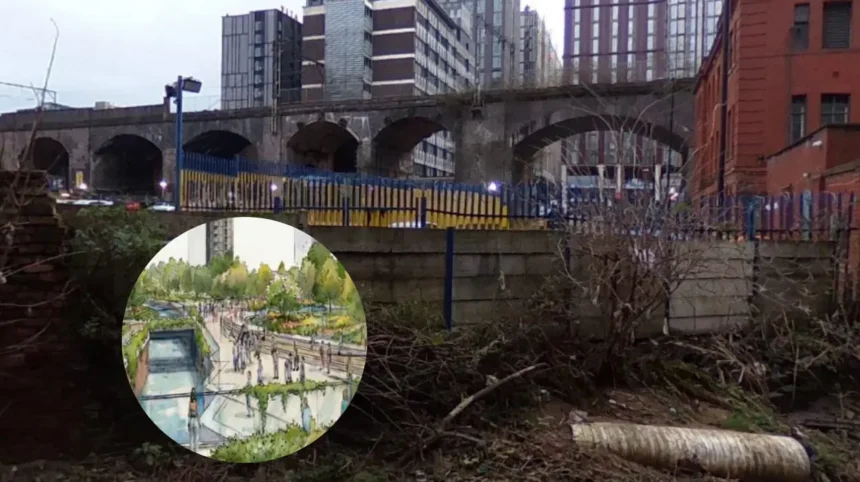
- A major new urban park, roughly the size of Mayfield Park (about 6.5 acres), is proposed along the River Medlock, designed to be climate‑resilient and inclusive.
- The update to the 2016–17 framework will guide future planning applications and investment, with the aim of creating a coherent, mixed‑use district that links better to Castlefield, St John’s and the wider city centre.
- The consultation runs until 25 May 2026, after which the council will consider feedback before finalising the Strategic Regeneration Framework.
Manchester Council(Manchester Mirror)May 16,2026-Manchester City Council has unveiled a sweeping new vision for the Water Street area, proposing a large‑scale residential‑led district that would include thousands of homes, a major new park along the River Medlock, and upgraded walking and cycling links through one of the city centre’s last undeveloped tracts.
As reported by Manchester City Council in its official news‑stories channel, the updated Strategic Regeneration Framework (SRF) for Water Street is being put out to public consultation to shape how the site will be developed over the coming decade. The framework is intended to act as a “master plan” for future planning applications, balancing private investment with affordable housing, green space and community amenities.
Local planners stress that the Water Street area, tucked between St John’s, Castlefield, the A57 and the River Irwell, represents one of the final “forgotten” pockets in central Manchester where large‑scale regeneration can still take place. The council’s city centre regeneration team has described the corridor as an opportunity to knit together existing neighbourhoods, improve connectivity severed by earlier highway layouts, and respond to rising demand for homes and green space.
What is the new Water Street plan?
According to council documents filed under the Water Street consultation, the draft SRF from 2026 proposes a new neighbourhood with “mostly homes” alongside a substantial public park that follows the banks of the River Medlock. The plan signals a shift from the earlier 2016–17 framework by raising the ambition for both the scale of housing and the quality of the public realm.
As described by Manchester City Council in its regeneration briefing, the SRF would guide a residential‑led mix of uses, including ground‑floor retail, hospitality and community facilities, to avoid the area becoming a purely “dormitory” zone. The council’s narrative also states that affordable homes will be “strongly represented” within the overall mix of tenures, without specifying a fixed percentage at this stage.
The new park is framed as a climate‑resilient green corridor, potentially similar in size to the 6.5‑acre Mayfield Park nearby, with buildings designed to partially shield it from the noise and pollution of the inner‑ring‑road frontage. The council’s documents suggest flexible, inclusive spaces that could host events, play, and everyday recreation, rather than a formal “decorative” green space disconnected from surrounding streets.
How will connectivity and movement change?
In the Water Street consultation portal, the council outlines a series of improvements to pedestrian and cycle routes, aiming to repair long‑standing breaks in the city‑centre street network created by 1960s road infrastructure. The plan points specifically to better links between the Water Street area, Castlefield, St John’s and the wider retail and business core of the city centre.
As described by the council’s city centre regeneration team, the SRF looks at where crossings, under‑crofts and viaduct arches can be re‑activated to create “through” routes rather than dead‑end pockets. The documents also flag new uses for the viaduct arches, such as small businesses, studios or community spaces, as part of a broader mixed‑use strategy.
Local transport and planning coverage notes that the scheme aligns with Manchester’s wider ambitions to prioritise walking and cycling over car‑centric design, while still accommodating the practical need for deliveries and access to the city centre. The consultation asks residents and businesses to comment on proposed routes, the balance of vehicle and foot traffic, and the potential for “low‑traffic” streets in the new neighbourhood.
What is the housing and skyline impact?
Commenting on the housing dimension, the council’s regeneration lead for the city centre has stated that Water Street offers one of the few remaining opportunities in central Manchester to deliver large‑scale residential schemes that can meet housing demand while generating investment for public space and infrastructure. The existing 2016 framework has already led to the construction of Vista River Gardens on the nearby Trinity Island site, a 1,950‑home scheme delivered across four towers of between 39 and 60 storeys.
According to the council’s SRF update, the Water Street area similarly allows for several tall residential towers, though the exact number and heights will be determined through the statutory planning process once the framework is adopted. The documents emphasise that the towers would be arranged so their massing supports the proposed park and avoids creating long, monolithic frontages along the street.
Affordable housing is flagged repeatedly in the council’s public‑facing materials. The regeneration team has stated that a “significant” proportion of the new homes will be affordable, with the precise percentage to be negotiated with developers as individual schemes are brought forward. That wording reflects the council’s reliance on market‑led development, but also signals an intention to secure more social and affordable stock than in earlier city‑centre schemes.
Who supports the plan, and what concerns exist?
The council’s position is that the Water Street SRF supports its wider city‑centre goals, including economic growth, job creation in construction and services, and stronger neighbourhoods. In a statement included in the consultation papers, the council’s executive lead for city centre and regeneration has described the site as “one of the final pieces of the central Manchester regeneration jigsaw,” framing it as a chance to complete a more coherent core‑city fabric.
However, as highlighted in coverage by housing and planning trade outlets such as Housing Today, some commentators have raised questions about the cumulative impact of multiple tall residential towers in the western city centre, including shadows, wind‑tunnel effects and pressure on local infrastructure. The council’s own documents acknowledge that the framework must be tested against technical studies on energy, drainage and transport capacity, which will be refined as individual applications are submitted.
Community‑engagement clauses in the consultation invite nearby residents, businesses and advocacy groups to comment on noise, light, access, and the quality of the proposed park. The council has also set out that military‑era flood‑risk data and climate‑resilience modelling will inform how the River Medlock corridor is designed, again to address concerns about water levels and green‑space viability.
Background to Water Street’s regeneration
The Water Street area has long been described as an underused slice of land hemmed in by the River Irwell, the A57, and the older Castlefield basin. Before the 2016 SRF, the site was largely a mix of light industrial units, car parks and low‑rise service buildings, with only patchy private investment and limited public access to the riverfront.
The 2016–17 framework already allowed for residential‑led development and the first phase of transformation around Trinity Island, which has since seen the start of the Vista River Gardens scheme. The 2026 update effectively expands the ambition to the remaining undeveloped parcels, treating the whole Water Street corridor as a single, continuous regeneration zone rather than a series of disconnected plots.
Local planning professionals observe that the site’s proximity to MediaCityUK, Spinningfields, and the St John’s/Castlefield retail and leisure clusters has helped make it attractive to private investors, while the council’s insistence on a public park and mixed uses aims to ensure the area does not become a purely “bedroom” extension to the city centre.
How this development could affect particular audiences
For Manchester homeowners and renters, the Water Street plan could influence housing supply and prices in the western city centre, particularly if several thousand new homes are delivered over the next decade. The extent to which the affordable‑housing component translates into genuinely below‑market rents will be a key factor for local residents concerned about gentrification and displacement pressures.
For local businesses in Castlefield, St John’s and along the A57 corridor, the forecast of new retail and hospitality uses at the ground‑floor level could bring more footfall and customers, but also more competition and changes in traffic patterns. Existing small‑business owners may watch closely how the council balances private investment with the protection of local‑trader viability and the character of nearby streets.
For commuters and visitors, the proposed upgrades to walking and cycling links could make the Water Street area more accessible on foot or by bike, while the new park offers an additional green destination within the city centre. Conversely, construction of several tall towers and associated infrastructure may temporarily disrupt traffic and access, particularly around the A57 and connecting routes.
For regional and national planners, the Water Street SRF may serve as a case study in how cities can reconcile high‑density residential development with climate‑resilient green space and connectivity in formerly “forgotten” highway‑adjacent sites. The outcome of the 2026 consultation and how the council translates public feedback into the final version of the framework will be closely watched by other local authorities grappling with similar brownfield‑site challenges.