Liverpool Road Manchester is a historic thoroughfare located in the Castlefield district within the southwestern sector of Manchester city centre. It extends from the Deansgate arterial corridor to the River Irwell boundary, connecting the city core to Salford.
- How Did Liverpool Road Manchester Develop During the Industrial Revolution?
- What Are the Key Architectural and Historical Landmarks on Liverpool Road Manchester?
- What Role Does the Science and Industry Museum Play on Liverpool Road Manchester?
- How Has Liverpool Road Manchester Transformed Through Urban Regeneration?
- What Is the Infrastructure and Transport Connectivity of Liverpool Road Manchester?
- What Is the Future Economic and Cultural Impact of Liverpool Road Manchester?
- Frequently Asked Questions
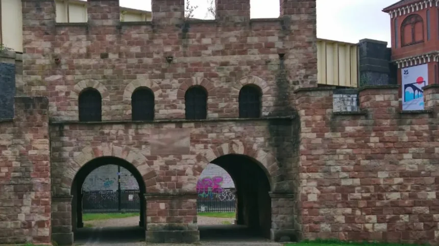
Liverpool Road runs through the protected Castlefield Conservation Area in the M3 postcode sector of Greater Manchester. The street connects Deansgate on its eastern end to the Water Street and Regent Road corridors on its western edge. The geographic coordinates place the road directly adjacent to the historic Roman fort site of Mamucium established in 79 AD. The corridor covers a distance of approximately 0.8 kilometres within the urban grid. It forms a key boundary for the southern canal system, running parallel to the Rochdale Canal basin.
The modern street layout retains the eighteenth-century grid pattern established during the early Industrial Revolution. Land use along the street comprises listed historical structures, educational facilities, residential apartment developments, and cultural institutions. The street sits within the municipal jurisdiction of Manchester City Council. Transport links include proximity to the Deansgate-Castlefield Metrolink station and the Deansgate railway station at the eastern terminus. The geographical location makes Liverpool Road a central axis for urban heritage tourism and regional infrastructure connectivity.
How Did Liverpool Road Manchester Develop During the Industrial Revolution?
Liverpool Road Manchester developed as a vital industrial corridor following the opening of the Liverpool and Manchester Railway in 1830. The establishment of the world’s first intercity passenger station transformed the street into a major commercial logistics node.
The primary catalyst for the growth of Liverpool Road was the opening of the Liverpool and Manchester Railway on September 15, 1830. The site was selected by chief engineer George Stephenson due to its proximity to the terminus of the Bridgewater Canal. The Liverpool Road railway station served as the original terminus for both passenger and goods traffic. Passenger operations moved to Victoria Station in 1844, turning Liverpool Road into a specialized freight goods yard.
The London and North Western Railway expanded the complex between 1850 and 1880 by constructing massive bonded warehouses. These structures stored cotton, timber, grain, and manufactured coal products arriving from northern industrial sites. The growth of the railway led to the construction of specialized merchant premises, iron foundries, and worker housing along the street. The heavy concentration of transport infrastructure established Liverpool Road as an international model for multi-modal freight handling. Railway operations at the site continued continuously for 150 years until British Rail decommissioned the goods yard in September 1975.
What Are the Key Architectural and Historical Landmarks on Liverpool Road Manchester?

The primary landmarks on Liverpool Road Manchester include the Grade I listed 1830 Station, the Science and Industry Museum, and the 1830 Warehouse. The street features exceptional examples of Victorian industrial masonry, ironwork, and railway infrastructure.
The Liverpool Road Station building is recognized as the oldest surviving passenger railway station in the world. The structure features a Georgian stucco facade with classical proportions, designed by architect John Rastrick. Adjoining the station is the 1830 Warehouse, a three-story brick structure built to transfer goods between rail wagons and canal barges. The site includes the 1855 Power Hall, which originally housed steam engines and railway machinery. Further west along the street sits the Grade II listed High Level Warehouse constructed in 1880. The streetscape contains traditional red brick facades, cast-iron support columns, stone setts, and timber loading bays.
Victorian pub architecture remains preserved in structures like the Oxnoble, which has traded on Liverpool Road since 1804. The canal viaducts engineered by Stephenson cross the street using original brick arches and iron girders. Nearby developments preserve former industrial sites, such as the Potato Wharf merchant yards and timber storage basins. These structures form an intact architectural record of nineteenth-century engineering methods.
What Role Does the Science and Industry Museum Play on Liverpool Road Manchester?
The Science and Industry Museum occupies the former Liverpool Road railway station complex and operates as a major cultural institution. It preserves the industrial heritage of Greater Manchester through extensive technology exhibits, working machinery, and educational programs.
The museum opened at the Liverpool Road site in 1983 after acquiring the abandoned British Rail property. It spans five historic buildings across a seven-acre footprint along Liverpool Road and Lower Byrom Street. The museum holds collections detailing the development of computing, textile manufacturing, public sanitation, and transport engineering. Key exhibits include a replica of the 1829 Planet locomotive and working Jacquard looms from nineteenth-century cotton mills.
The museum forms part of the Science Museum Group, attracting over 800,000 visitors annually prior to facility renovations. Educational programs at the site serve primary, secondary, and higher education institutions across the United Kingdom. The ongoing restoration masterplan aims to repair the historic 1830 Warehouse and improve energy efficiency across all heritage buildings. The museum acts as the primary anchor institution for cultural tourism along the Liverpool Road corridor. Its presence prevents commercial demolition and ensures public access to Grade I listed national infrastructure.
How Has Liverpool Road Manchester Transformed Through Urban Regeneration?
Liverpool Road Manchester transformed from a derelict industrial zone into a high-density mixed-use district through urban regeneration efforts initiated in the 1980s. The process combined historic conservation with modern residential and commercial development.
Regeneration along Liverpool Road began following the designation of Castlefield as the United Kingdom’s first Urban Heritage Park in 1982. Central government grants and Manchester City Council initiatives funded the restoration of derelict warehouses and historic canal basins. Private developers converted disused nineteenth-century goods sheds into modern residential apartments, offices, and leisure venues. Derelict land along Potato Wharf was redeveloped into multi-story residential blocks to accommodate growing city centre populations. Cobblestone street surfaces, historic street lighting, and iron canal bridges were systematically restored to preserve streetscape identity.
Planning regulations enforced strict heritage design standards on new construction to maintain architectural harmony with Victorian structures. The influx of new residents supported the growth of independent restaurants, cafes, and hospitality businesses along the street. Public realm improvements included pedestrianized plazas, green walkways, and heritage signage explaining local industrial history. Regeneration turned Liverpool Road into a premier residential location while maintaining its international historic status.
What Is the Infrastructure and Transport Connectivity of Liverpool Road Manchester?
Liverpool Road Manchester possesses strong transport connectivity through a network of light rail, heavy rail, pedestrian routes, and road links. It integrates the Castlefield historic core with the broader Greater Manchester urban transport grid.
The corridor connects directly to the A56 Deansgate road axis, providing vehicular access to inner ring roads. The Deansgate-Castlefield Metrolink tram stop sits within 200 metres of the eastern end of Liverpool Road. This light rail hub provides direct connections to Manchester Victoria, Manchester Piccadilly, Altrincham, and Manchester Airport. Heavy rail services operate from Deansgate station, offering regional commuter routes across the North West. Pedestrian routes follow the Rochdale Canal towpaths, connecting Liverpool Road to Wharf Street and the Bridgewater Canal basin.
The street features dedicated cycle paths and pedestrian crossings to manage traffic safety near museum entrances. Bus services run along Deansgate and Regent Road, offering frequent local transport coverage. Nearby highway links provide connection to the A57(M) Mancunian Way, facilitating access to regional motorway networks. Transport infrastructure along Liverpool Road balances commercial logistics, resident commuting, and heavy pedestrian traffic from tourists.
What Is the Future Economic and Cultural Impact of Liverpool Road Manchester?
The future impact of Liverpool Road Manchester centers on continued cultural investment, sustainable urban housing, and heritage tourism expansion. It remains a key economic driver for the southwestern quadrant of Manchester city centre.
Economic activity along Liverpool Road is driven by museum visitors, hospitality revenue, and residential property values. Multi-million-pound capital investments by the Science and Industry Museum aim to update exhibition spaces and restore original structures. Future urban plans prioritize net-zero carbon goals, integrating green energy technology into sensitive historic buildings. The growth of the adjacent St John’s and Factory International cultural districts increases foot traffic along Liverpool Road.
Property demand along the street remains strong due to its historic architecture and central location. Heritage preservation policies ensure that future development does not compromise the structural integrity of listed assets. Local business associations promote events, walking tours, and cultural festivals that draw regional and international visitors. Liverpool Road serves as a global case study for transforming industrial infrastructure into sustainable urban centers. The ongoing integration of heritage, commerce, and culture guarantees its continued economic relevance for Manchester.
Frequently Asked Questions
What is Liverpool Road in Manchester famous for?
Liverpool Road in Manchester is famous for housing the world’s first intercity passenger railway station, opened in 1830. It served as the original terminus for the historic Liverpool and Manchester Railway engineered by George Stephenson. Today, the preserved complex forms part of the Science and Industry Museum in Castlefield.
Is Liverpool Road Manchester located in Castlefield?
Yes, Liverpool Road is located entirely within the historic Castlefield district in southwestern Manchester city centre. It runs parallel to the Rochdale Canal and is central to the Castlefield Conservation Area. The street is easily accessible from the Deansgate-Castlefield Metrolink station.
What can you see at the Science and Industry Museum on Liverpool Road?
Visitors can explore historic railway buildings, original working textile machinery, and early computing technology exhibits. Key highlights include the Grade I listed 1830 Station and the interactive Power Hall. The museum offers extensive educational displays detailing Manchester’s pivotal role in the Industrial Revolution.
Are there good places to eat and drink on Liverpool Road Manchester?
Liverpool Road features several historic pubs, modern cafes, and independent restaurants along its corridor. The famous Oxnoble pub has served food and drink on the street continuously since 1804. Additional dining options exist around the Potato Wharf and nearby Castlefield Basin areas.
How do I get to Liverpool Road using public transport?
You can reach Liverpool Road by taking the Metrolink tram to the Deansgate-Castlefield station. National Rail services stop nearby at Deansgate station, located just a short walk from the street. Local city centre bus routes also stop along Deansgate and Regent Road near the site.