Key Points
- Manchester City Council closed the northbound carriageway of Alan Turing Way between Ashton Old Road and Grey Mare Lane in late March 2026 after a surface depression appeared in the roadway.
- Specialist engineering consultants determined the void was caused by an unrecorded historical mine shaft measuring approximately three metres wide and 50 metres deep, rather than an initially suspected utility failure.
- Manchester City Council confirmed the damage is isolated to the immediate stretch of Alan Turing Way, posing no risk of further ground collapse to surrounding properties or the wider area.
- Ground investigations and repair works have been supported by designer Waterman alongside contractors Rosgal, V.J. Donegan and Co, and Soil Engineering Geoservices.
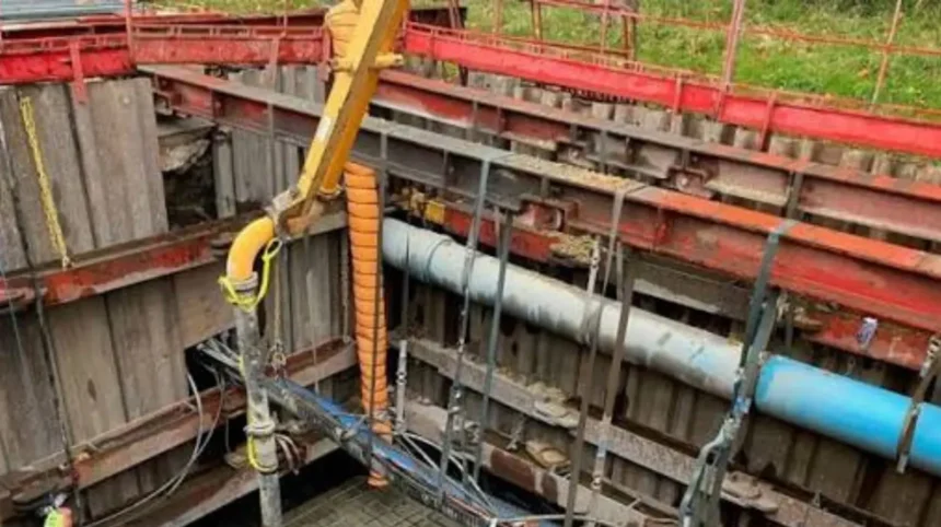
- Engineers navigated complex underground obstacles, including United Utilities and Openreach infrastructure running across an initial shored excavation measuring 6.4 metres by 6.3 metres and reaching six metres below ground level.
- Stabilisation work began on 17 September 2026 with the injection of more than 100 tonnes of cement-based grout, followed by the installation of a reinforced concrete cap completed on 25 October and lightweight concrete fill completed on 31 October.
- Utility coordination and final void backfilling are underway ahead of road reconstruction, with Manchester City Council targeting a mid-December 2026 reopening for the northbound carriageway.
Manchester (Manchester Mirror) November 20, 2026 – Road repair and ground stabilisation works are advancing beneath Alan Turing Way in east Manchester after specialist engineering consultants identified an unrecorded historical mine shaft as the cause of a major carriageway collapse that forced the closure of the northbound route between Ashton Old Road and Grey Mare Lane in late March 2026.
- Key Points
- What caused the road depression on Alan Turing Way?
- How did engineers investigate the underground void?
- What are the five phases of the Alan Turing Way repair programme?
- Phase 1: Making the mine shaft safe
- Phase 2: Installing a reinforced concrete slab
- Phase 3: Adding lightweight concrete fill
- Phase 4: Utility protection and void backfilling
- Phase 5: Rebuilding and reopening the road
- What have officials and residents said about the disruption?
- Background
- Prediction
What caused the road depression on Alan Turing Way?
As reported by Ground Engineering, Manchester City Council began investigating a depression in the road surface on Alan Turing Way in late March 2026, prompting the immediate closure of the northbound section of the busy arterial route between Ashton Old Road and Grey Mare Lane. While initial speculation pointed toward a standard utility failure beneath the tarmac, intrusive ground investigations by specialist engineering consultants revealed an unrecorded historical mine shaft measuring approximately three metres wide and extending roughly 50 metres below the road surface.
According to Manchester City Council, officials emphasised that the source of the structural damage is strictly isolated to the immediate footprint beneath Alan Turing Way and presents no risk of further surface collapse or damage to surrounding properties and neighbouring areas. Nevertheless, the local authority stressed that the deep underground void required comprehensive stabilisation and backfilling to guarantee the long-term structural integrity and safety of the carriageway before traffic could safely return.
How did engineers investigate the underground void?
As reported by Ground Engineering, Manchester City Council’s highways team enlisted designer Waterman alongside specialist contractors Rosgal, V.J. Donegan and Co, and Soil Engineering Geoservices to execute the complex ground investigations and remediation programme. Crews initially accessed the site through a shored excavation designed to determine the root cause and map the physical extent of the subsurface collapse.
As reported by Ground Engineering, a Manchester City Council spokesperson stated that
“The excavation was approximately 6.4m by 6.3m in extent, with soft made ground recorded to approximately 6m below ground level (bgl) where natural deposits were encountered. A smaller area of around 3m by 2m immediately beneath the location where the feature initially formed was found to contain a greater thickness of made ground.”
Both the ground investigation and subsequent treatment operations were heavily complicated by the depth of the initial excavation and the presence of live United Utilities and Openreach infrastructure spanning directly across the open void. Addressing the technical measures taken to overcome these constraints, the Manchester City Council spokesperson added to Ground Engineering that
“Ground investigation was completed in the area surrounding the excavation and from a drilling platform constructed over the excavation.”
As reported by Marc Hobbins of Highways & Construction News and Jack Moriarty of Highways Industry, specialist contractors drilled approximately 50 metres beneath the carriageway to assess deep ground conditions before engineers could finalise a permanent structural design. As reported by George Lythgoe of the Manchester Evening News, the lengthy subterranean investigation led to frustration among some local residents who perceived a lack of visible surface activity, prompting council officials to clarify that extensive engineering work was taking place below ground level.
What are the five phases of the Alan Turing Way repair programme?
According to project schedules published by Manchester City Council and detailed by Alice Lorenzato-Lloyd of Secret Manchester, engineers divided the remediation of the 50-metre void into five distinct operational phases, with crews typically working from Monday to Saturday:
Phase 1: Making the mine shaft safe
Intrusive ground investigations concluded in mid-September, allowing primary stabilisation works to begin on 17 September 2026. Contractors pumped more than 100 tonnes of cement-based grout into the mine shaft and surrounding strata to fill subterranean gaps, consolidate loose material, and prevent further ground movement. Manchester City Council confirmed this phase was completed in early October 2026.
Phase 2: Installing a reinforced concrete slab
Commencing on 12 October 2026, contractors constructed a large steel-reinforced concrete cap directly over the head of the grouted mine shaft. As observed on site by George Lythgoe of the Manchester Evening News on 21 October 2026, contractors worked approximately 10 metres below the road surface to level and reinforce the concrete lid. Manchester City Council confirmed the reinforced concrete slab was completed on 25 October 2026, establishing a permanent structural seal to distribute traffic loads from the carriageway above.
Phase 3: Adding lightweight concrete fill
Following the curing of the structural concrete cap, engineers placed a layer of lightweight concrete fill above the slab to provide structural support while minimising downward weight pressure on the capped shaft. Manchester City Council recorded the completion of this phase on 31 October 2026.
Phase 4: Utility protection and void backfilling
Throughout November 2026, crews have focused on carefully backfilling the remaining six-metre-deep excavation in planned stages while working alongside United Utilities, Openreach, and other telecommunications providers. Water, telecoms, and internet companies have been required to protect and repair their respective cables and infrastructure passing through the trench to maintain service reliability across east Manchester.
Phase 5: Rebuilding and reopening the road
Once utility repairs and backfilling are verified as complete and safe, highways crews will reconstruct the road base, install drainage, lay new tarmac surfacing, and reinstate road markings. Manchester City Council currently expects the works to finish by mid-December 2026, though officials noted the schedule remains subject to adverse weather conditions or unforeseen site issues.
What have officials and residents said about the disruption?
As reported in an official statement released by Manchester City Council, Councillor Mandie Shilton Godwin, Executive Member for Clean Air, Environment and Transport, stated that
“I’d like to thank residents and local businesses for their patience as we carried out our investigations along Alun Turing Way. No one could have anticipated the scale of the void that we found but, once it became apparent, all of our effort went into making sure the site was safe and the road could be reopened. This has been a considerable task, requiring the input of specialists to ensure the void is properly backfilled and stabilised. The preliminary works have now taken place and work will now press on to install a concrete cap over the mine shaft head and then repair the remaining utility connections and finally the surface of the road.”
As reported by George Lythgoe of the Manchester Evening News, Councillor Mandie Shilton Godwin also noted during a site visit that she had wanted to descend into the excavation to inspect the works firsthand, though health and safety regulations prevented her from doing so.
Meanwhile, the prolonged closure has caused substantial daily congestion for east Manchester commuters. As reported by Marc Hobbins of Highways & Construction News via the Local Democracy Reporting Service, Newton Heath resident David Carey stated that a regular journey which normally took approximately 20 minutes had stretched to more than an hour due to traffic diversions and congestion surrounding the closed carriageway.
Background
East Manchester possesses an extensive industrial and coal mining heritage dating back to the 18th and 19th centuries, particularly around Bradford, Clayton, Beswick, and Newton Heath. During rapid Victorian industrial expansion, numerous collieries and exploratory shafts were sunk across the region, many of which were abandoned, loosely backfilled, or inadequately documented before modern statutory mining records were established. While Manchester City Council noted that surface collapses linked to legacy mining infrastructure are relatively uncommon in the modern era, unrecorded shafts beneath major urban corridors remain a recognised geotechnical hazard across former coalfield regions of northern England. Alan Turing Way serves as a vital north-south arterial link connecting east Manchester residential neighbourhoods, commercial districts, and major sporting and entertainment venues, making any extended closure a significant disruption to the city’s wider transport network.
Prediction
For daily commuters, local residents in Newton Heath and Beswick, and east Manchester businesses, the scheduled mid-December 2026 reopening of the northbound carriageway is expected to alleviate severe peak-hour bottlenecks along Ashton Old Road, Grey Mare Lane, and surrounding diversion routes. Journey times—which residents reported had tripled from 20 minutes to over an hour—should progressively return to normal once full two-way capacity is restored prior to the busy winter holiday period. For Manchester City Council and regional civil engineering contractors, the structural capping and grouting of the 50-metre shaft will eliminate the long-term risk of recurring subsidence along this section of Alan Turing Way, while protecting critical United Utilities water mains and Openreach telecommunications networks from future ground movement. However, should winter weather conditions delay final surfacing in early December, motorists and local freight operators could face extended diversion pressures into the new year.